
Kassel
Drahtbrücke, 34123 Kassel, Deutschland
Wire Bridge Kassel | History & Parking
The Wire Bridge in Kassel is much more than just a short crossing over the Fulda. It is an urban link between the bank, park landscape, and neighborhood, a historic pedestrian bridge with high recognition value, and at the same time a place where one experiences Kassel particularly directly. Upon entering the Wire Bridge, one immediately feels why this place is so often associated in search intent with terms like Kassel, Maps, open again, history, parking, and access: The bridge is clearly located, easily found, and closely connected to urban life by the river. Officially, it lies between Auedamm and Sternstraße, and this location makes it an important connection between Karlsaue, Unterneustadt, and the city center. At the same time, it is a place where nature, city, and movement merge. The Fulda, which flows through Kassel, is not just a backdrop here but part of the path. Therefore, the Wire Bridge is suitable for short walks as well as for longer tours along the river paths, through green spaces, and into the neighboring neighborhoods. As a historic structure with modern use, it remains one of the prominent faces of Kassel by the water. ([kassel.de](https://www.kassel.de/daten-und-karten/statistik/strassenverzeichnis-und-raeumliche-gliederung.php.media/152854/StrvzKS_A_Z.pdf))
History of the Wire Bridge: From Ferry to Suspension Bridge
The history of the Wire Bridge goes back much further than the current structure itself. After the old city fortifications were demolished under Landgrave Friedrich II around 1770, a seasonal ferry bridge was initially built at the site of the current bridge, which was erected in summer. This early connection existed until the 1840s and was then replaced by a ferry. As early as 1813, there were design drawings by Heinrich Christoph Jussow for a three-arch stone bridge at the same location, indicating that the crossing over the Fulda was considered an important urban space early on. The current Wire Bridge was finally opened for pedestrian traffic on November 1, 1870, and was built by Henschel. In its early days, it was privately owned and subject to a fee; until March 31, 1896, one had to pay to cross. Only then did it become the property of the city, and its use became free. Thus, a technical solution transformed into an open public urban space that continues to shape the everyday life of the Kassel population to this day. ([de.wikipedia.org](https://de.wikipedia.org/wiki/Drahtbr%C3%BCcke))
The following decades were not without burdens. In the winter of 1940, the bridge was damaged by ice masses because the bathing bridge had been washed away; the sidewalk segments and the two pylons had to be replaced by new constructions. In May 1943, a severe flood situation arose, triggered by the destruction of the Edersee dam, whose water masses penetrated through the Eder and Fulda valleys to Kassel. The Wire Bridge was again damaged as a result. In 1945, bomb damage additionally affected the structure, but it could be used again as early as 1946. Later, in 1955, the bridge was reinforced with an additional pillar in the middle of the river, which was removed in 1997 during a comprehensive renovation after the self-stability of the suspension bridge had been renewed. The work included, among other things, the restoration of the pylons, the filling of the abutment hollow spaces, and the renewal of the sidewalk segments. After a three-month closure, the bridge was reopened for pedestrians and cyclists. This history makes the Wire Bridge a rare Kassel structure that tells of technical, urban historical, and social developments alike. ([de.wikipedia.org](https://de.wikipedia.org/wiki/Drahtbr%C3%BCcke))
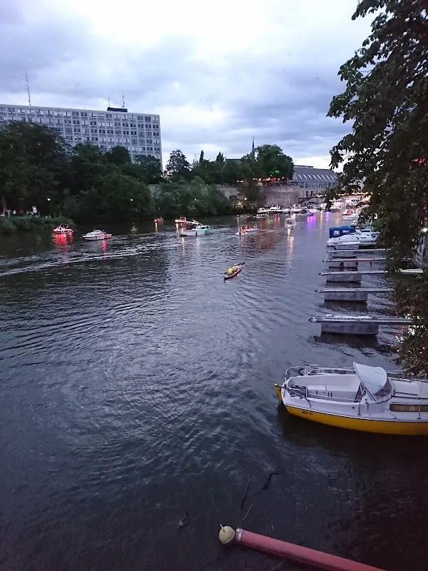
Where is the Wire Bridge in Kassel?
Those searching for the Wire Bridge on the map will find it in the immediate river area of the Fulda in Kassel. The city of Kassel officially lists it as a pedestrian bridge over the Fulda between Auedamm and Sternstraße. This location is particularly important for orientation, as it clearly anchors the bridge in the urban structure and clarifies its function as a crossing between the east and the city center. The Wire Bridge is also located directly north of the Hessenkampfbahn, thus connecting an area shaped by sports, green spaces, and urban paths. In the historical and spatial development of Kassel, it is the bridge that makes the Fulda most palpable as a pedestrian connection. Precisely because it does not appear as a grand automobile bridge, but as a narrow, clearly defined crossing, its location remains easily readable. One enters it from the river paths, simultaneously sees water, park, and neighborhood, and feels how closely nature and city are intertwined in Kassel. ([kassel.de](https://www.kassel.de/daten-und-karten/statistik/strassenverzeichnis-und-raeumliche-gliederung.php.media/152854/StrvzKS_A_Z.pdf))
The immediate surroundings of the Wire Bridge are also characteristic of Kassel. On one side lie Karlsaue and Fulda-Aue, on the other the Unterneustadt with its historical development east of the river. The bridge is thus not only a way over water but also a transition between different urban spaces, each possessing its own qualities. The city even describes the Drusel in its green space as flowing into the Fulda between the Wire Bridge and Rondell, which further highlights the location as a water junction. Those planning a walk that includes the Wire Bridge can connect it with Karlsaue, the Fulda riverbank, and a tour through Unterneustadt. This is precisely where the local search value of terms like Kassel Maps, Unterneustadt, or Auedamm arises: The bridge is not isolated but part of a coherent, easily walkable urban space. ([kassel.de](https://www.kassel.de/buerger/kunst_und_kultur/parks_und_gaerten/unbekannte-freiraeume/druselgruenzug.php))
Pedestrian and Bicycle Traffic over the Fulda
The Wire Bridge is particularly significant for everyday life as a pedestrian and bicycle connection. In the urban street overview, it is listed as a pedestrian bridge, and in practice, it has long been part of the network of paths that allow crossing the Fulda without detours. This is precisely what makes its special value: it is short, direct, and scenically attractive. Pedestrians experience an open view of the river and the riverbanks while cyclists use the bridge as part of a riverside route. The Wikipedia documentation explicitly calls it a pedestrian suspension bridge that may also be used by cyclists. For a city like Kassel, where bike and footpaths along the Fulda are becoming increasingly important, this mix of history and everyday utility is particularly valuable. Therefore, the bridge is not only a monument but a functioning traffic space in the best sense: slim, robust, central, and seamlessly integrated into the landscape. ([kassel.de](https://www.kassel.de/daten-und-karten/statistik/strassenverzeichnis-und-raeumliche-gliederung.php.media/152854/StrvzKS_A_Z.pdf))
From the perspective of urban use, the Wire Bridge fits into Kassel's understanding of the river space. The Fulda is described by the city as a blue ribbon that brings together sports, leisure, and everyday mobility. Along Auedamm, traffic flows are captured and managed, demonstrating how strongly this space is anchored in the urban mobility network. The Wire Bridge lies precisely in this tension between a quiet footpath and a lively river corridor. This is why it is so relevant for search queries like pedestrian bridge Kassel, suspension bridge Kassel, or Fulda Bridge Kassel: it connects not only two banks but also two types of use, namely the short route from A to B and the experience of urban landscape. Those using the bridge consciously move slower than in car traffic and experience the transition from greenery, water, and buildings immediately. This is precisely what makes it appealing for walks, photo excursions, and light bike tours. ([kassel.de](https://www.kassel.de/buerger/kunst_und_kultur/parks_und_gaerten/fuldaaue.php?utm_source=openai))
Fulda, Karlsaue, and the Surroundings by the Water
The special quality of the Wire Bridge arises from its location in the water area of the city. The Fulda shapes Kassel as a landscape and urban planning element, and the Wire Bridge lies right in the middle of this axis. The city of Kassel describes the Fulda-Aue as a large nature reserve just a few minutes from the city center, and this provides the scenic framework in which the bridge is experienced. In close proximity are Karlsaue, waterfront promenades, green spaces, and other river crossings. Additionally, the Drusel flows into the Fulda between the Wire Bridge and Rondell. Thus, the location is not only a crossing point but also a water junction in the urban landscape. Those who view the location merely as a bridge underestimate its impact: in reality, it is part of a citywide relationship between water, paths, and open space. This is why search terms like Karlsaue Kassel and Auedamm Kassel work so well, as the bridge is not situated off to the side but in a densely interconnected recreational and natural space. ([kassel.de](https://www.kassel.de/buerger/kunst_und_kultur/parks_und_gaerten/fuldaaue.php?utm_source=openai))
For visitors, this means: The Wire Bridge is an ideal starting point for a short or longer riverside walk. One can walk along the Fulda, enter Karlsaue, or continue from here into Unterneustadt. The bridge itself does not offer a tourist presentation in an overloaded sense, but rather a calm, clear perspective on the city and landscape. This is precisely what makes it so popular. In Kassel, the river space is not just a backdrop but a lived part of the city. Therefore, the Wire Bridge stands alongside other places where Kassel shows its relationship with water: at Auedamm, along the river paths, and at the open green spaces of the Fulda. Those searching for the bridge on the map should not read it as an isolated attraction but as part of a movement line between the city center, river, and park. This also aids in the practical planning of a visit, as a single stop can easily lead to a larger tour. ([kassel.de](https://www.kassel.de/buerger/kunst_und_kultur/parks_und_gaerten/fuldaaue.php?utm_source=openai))
Cultural Tent, Zissel, and Events at the Wire Bridge
The Wire Bridge is not only a historic crossing but also a place where Kassel showcases its summer cultural side. Particularly well-known is the cultural tent at the Wire Bridge, which has been an institution in the North Hesse cultural region since 1987. The city of Kassel describes it as a summer meeting point on the Fulda riverbank with cozy evenings, a diverse program, and a temporary beer garden. The cultural tent is scheduled to run from June 13 to July 11, 2026. The program ranges from rock and pop to funk, indie, hip hop, blues, jazz, and world music. Thus, the Wire Bridge is not only a way over the river in the warm season but also a cultural anchor point. Those searching for terms like events, program, or cultural tent at the Wire Bridge will land at a real, recurring event with regional impact. Since summer 2019, the tent has been set up by Zeltkultur, a non-profit organization that focuses on art with a stance. ([kassel.de](https://www.kassel.de/buerger/sport_und_freizeit/wiederkehrende-veranstaltungen/kulturzelt-an-der-drahtbruecke.php))
Other Kassel events also directly refer to the Wire Bridge as a location. During the Tiger Duck Race on Ascension Day, the regatta meadow at Auedamm lies between Spitzhacke and the Wire Bridge. The city mentions the date as May 14, 2026, starting at 11 a.m., and points out that on this day, Auedamm between Orangerie and Wire Bridge will be closed, and line 16 will not serve certain stops. This illustrates very well how closely the bridge space is connected to urban event life. Historically, the Wire Bridge was crossed by many visitors of the Kassel Zissel during the summer months, who walked from the fairground to the event area at Auedamm or back. Thus, the bridge becomes a place of collective movement: in summer for culture, during folk festivals for footpaths, and in everyday life for short routes across the Fulda. Therefore, those visiting the Wire Bridge not only experience construction history but also a lively environment that continues to attract events and continually revitalizes the place. ([www1.kassel.de](https://www1.kassel.de/buerger/sport_und_freizeit/wiederkehrende-veranstaltungen/tigerenten-rennen.php?utm_source=openai))
Access, Parking, and Practical Orientation
The most important recommendation for accessing the Wire Bridge is simple: the location is central and can be easily reached on foot, by bicycle, or via public transport. Since the bridge itself is only a pedestrian bridge over the Fulda, direct car traffic at the structure does not play a role. Therefore, those arriving by car should not attempt to park directly at the bridge but use the official parking facilities in Kassel's city center. The city lists City Point, Friedrichsplatz, Galeria, Kurfürsten Galerie, Martinskirche, Rathaus, and Wilhelmsstraße as parking garages and lots. This solution is particularly sensible if one wants to connect the Wire Bridge with a walk through the city center or Karlsaue. For search queries like parking Kassel city center or Wire Bridge Kassel Maps, this orientation is crucial: first find the central location, then choose the appropriate parking solution. ([kassel.de](https://www.kassel.de/buerger/verkehr_und_mobilitaet/mit-dem-auto/inhaltsseiten/parkhaeuser-parkplaetze-innenstadt.php?utm_source=openai))
It is also practical to consider the location of the bridge in relation to its surroundings. Those coming from the city center reach the Wire Bridge via the paths to Auedamm; those coming from Unterneustadt or Fulda-Aue approach it via the river areas. During events at Auedamm, there may be closures, as the example of the Tiger Duck Race shows. Then it is wise to reschedule in advance and possibly switch to a bike or public transport. Particularly because Kassel often gathers large crowds by the river, the Wire Bridge is a place where good planning saves time. For walks and photos, it is advisable to use the bridge as part of a route and not just as a one-time crossing point. This creates a well-rounded visit: over the bridge, along the water, into Karlsaue, or further into Unterneustadt. This is where the strength of this place lies. It is not spectacular in a loud sense but precise, city-shaping, and easily integrated into one's daily routine. ([www1.kassel.de](https://www1.kassel.de/buerger/sport_und_freizeit/wiederkehrende-veranstaltungen/tigerenten-rennen.php?utm_source=openai))
Practical Tips for Walks, Photos, and Excursions
Those visiting the Wire Bridge should understand it not only as a connection but also as a perspective. From here, the view opens up to the Fulda, the river paths, and the urban landscape between Karlsaue and Unterneustadt. This makes the location particularly attractive for quiet walks and short breaks. Because the bridge is located in an area characterized by greenery, water, and urban lines, the impression changes significantly depending on the time of day, weather, and season. In the morning, the place often appears still and clear, while in the evening it seems softer and more atmospheric. Particularly for people who want to discover Kassel on foot, the Wire Bridge serves as a starting or ending point for a tour. One can arrive here, cross the river, and then continue along the paths by the Fulda or through Karlsaue. In connection with the cultural tent or an event at Auedamm, this quickly becomes a whole city visit. Thus, the bridge is not only relevant for SEO keywords but also in real use as a small but very strong focal point of the Kassel river area. ([de.wikipedia.org](https://de.wikipedia.org/wiki/Drahtbr%C3%BCcke))
It is particularly helpful to place the Wire Bridge in the larger context of the Kassel river landscape. The city describes the Fulda as a defining natural and movement space, and the Wire Bridge lies exactly where this space is most strongly connected to the city center. Those visiting the location can easily combine multiple interests: a piece of city history, a walk by the water, a detour into Karlsaue, and if needed, a cultural evening by the Fulda riverbank. Therefore, for search intent, not only the name Wire Bridge is important but also everything that arises around it: Kassel Maps, Auedamm, Unterneustadt, Karlsaue, cultural tent, and parking. The bridge bundles this search world in a real, easily accessible place. For this reason, it remains a strong local motif for visitors who want to not only see Kassel but experience it on the go. ([kassel.de](https://www.kassel.de/buerger/kunst_und_kultur/parks_und_gaerten/fuldaaue.php?utm_source=openai))
Sources:
- City of Kassel – Street Directory / Wire Bridge ([kassel.de](https://www.kassel.de/daten-und-karten/statistik/strassenverzeichnis-und-raeumliche-gliederung.php.media/152854/StrvzKS_A_Z.pdf))
- Wire Bridge – Wikipedia ([de.wikipedia.org](https://de.wikipedia.org/wiki/Drahtbr%C3%BCcke))
- sbp – Wire Bridge over the Fulda ([sbp.de](https://www.sbp.de/projet/drahtbruecke-ueber-die-fulda/))
- City of Kassel – The Drusel Greenway ([kassel.de](https://www.kassel.de/buerger/kunst_und_kultur/parks_und_gaerten/unbekannte-freiraeume/druselgruenzug.php))
- City of Kassel – Fulda and Fulda-Aue ([kassel.de](https://www.kassel.de/buerger/kunst_und_kultur/parks_und_gaerten/fuldaaue.php?utm_source=openai))
- City of Kassel – Cultural Tent at the Wire Bridge ([kassel.de](https://www.kassel.de/buerger/sport_und_freizeit/wiederkehrende-veranstaltungen/kulturzelt-an-der-drahtbruecke.php))
- City of Kassel – Tiger Duck Race ([www1.kassel.de](https://www1.kassel.de/buerger/sport_und_freizeit/wiederkehrende-veranstaltungen/tigerenten-rennen.php?utm_source=openai))
- City of Kassel – Parking in Kassel City Center ([kassel.de](https://www.kassel.de/buerger/verkehr_und_mobilitaet/mit-dem-auto/inhaltsseiten/parkhaeuser-parkplaetze-innenstadt.php?utm_source=openai))
Mehr anzeigenWeniger anzeigen
Wire Bridge Kassel | History & Parking
The Wire Bridge in Kassel is much more than just a short crossing over the Fulda. It is an urban link between the bank, park landscape, and neighborhood, a historic pedestrian bridge with high recognition value, and at the same time a place where one experiences Kassel particularly directly. Upon entering the Wire Bridge, one immediately feels why this place is so often associated in search intent with terms like Kassel, Maps, open again, history, parking, and access: The bridge is clearly located, easily found, and closely connected to urban life by the river. Officially, it lies between Auedamm and Sternstraße, and this location makes it an important connection between Karlsaue, Unterneustadt, and the city center. At the same time, it is a place where nature, city, and movement merge. The Fulda, which flows through Kassel, is not just a backdrop here but part of the path. Therefore, the Wire Bridge is suitable for short walks as well as for longer tours along the river paths, through green spaces, and into the neighboring neighborhoods. As a historic structure with modern use, it remains one of the prominent faces of Kassel by the water. ([kassel.de](https://www.kassel.de/daten-und-karten/statistik/strassenverzeichnis-und-raeumliche-gliederung.php.media/152854/StrvzKS_A_Z.pdf))
History of the Wire Bridge: From Ferry to Suspension Bridge
The history of the Wire Bridge goes back much further than the current structure itself. After the old city fortifications were demolished under Landgrave Friedrich II around 1770, a seasonal ferry bridge was initially built at the site of the current bridge, which was erected in summer. This early connection existed until the 1840s and was then replaced by a ferry. As early as 1813, there were design drawings by Heinrich Christoph Jussow for a three-arch stone bridge at the same location, indicating that the crossing over the Fulda was considered an important urban space early on. The current Wire Bridge was finally opened for pedestrian traffic on November 1, 1870, and was built by Henschel. In its early days, it was privately owned and subject to a fee; until March 31, 1896, one had to pay to cross. Only then did it become the property of the city, and its use became free. Thus, a technical solution transformed into an open public urban space that continues to shape the everyday life of the Kassel population to this day. ([de.wikipedia.org](https://de.wikipedia.org/wiki/Drahtbr%C3%BCcke))
The following decades were not without burdens. In the winter of 1940, the bridge was damaged by ice masses because the bathing bridge had been washed away; the sidewalk segments and the two pylons had to be replaced by new constructions. In May 1943, a severe flood situation arose, triggered by the destruction of the Edersee dam, whose water masses penetrated through the Eder and Fulda valleys to Kassel. The Wire Bridge was again damaged as a result. In 1945, bomb damage additionally affected the structure, but it could be used again as early as 1946. Later, in 1955, the bridge was reinforced with an additional pillar in the middle of the river, which was removed in 1997 during a comprehensive renovation after the self-stability of the suspension bridge had been renewed. The work included, among other things, the restoration of the pylons, the filling of the abutment hollow spaces, and the renewal of the sidewalk segments. After a three-month closure, the bridge was reopened for pedestrians and cyclists. This history makes the Wire Bridge a rare Kassel structure that tells of technical, urban historical, and social developments alike. ([de.wikipedia.org](https://de.wikipedia.org/wiki/Drahtbr%C3%BCcke))
Where is the Wire Bridge in Kassel?
Those searching for the Wire Bridge on the map will find it in the immediate river area of the Fulda in Kassel. The city of Kassel officially lists it as a pedestrian bridge over the Fulda between Auedamm and Sternstraße. This location is particularly important for orientation, as it clearly anchors the bridge in the urban structure and clarifies its function as a crossing between the east and the city center. The Wire Bridge is also located directly north of the Hessenkampfbahn, thus connecting an area shaped by sports, green spaces, and urban paths. In the historical and spatial development of Kassel, it is the bridge that makes the Fulda most palpable as a pedestrian connection. Precisely because it does not appear as a grand automobile bridge, but as a narrow, clearly defined crossing, its location remains easily readable. One enters it from the river paths, simultaneously sees water, park, and neighborhood, and feels how closely nature and city are intertwined in Kassel. ([kassel.de](https://www.kassel.de/daten-und-karten/statistik/strassenverzeichnis-und-raeumliche-gliederung.php.media/152854/StrvzKS_A_Z.pdf))
The immediate surroundings of the Wire Bridge are also characteristic of Kassel. On one side lie Karlsaue and Fulda-Aue, on the other the Unterneustadt with its historical development east of the river. The bridge is thus not only a way over water but also a transition between different urban spaces, each possessing its own qualities. The city even describes the Drusel in its green space as flowing into the Fulda between the Wire Bridge and Rondell, which further highlights the location as a water junction. Those planning a walk that includes the Wire Bridge can connect it with Karlsaue, the Fulda riverbank, and a tour through Unterneustadt. This is precisely where the local search value of terms like Kassel Maps, Unterneustadt, or Auedamm arises: The bridge is not isolated but part of a coherent, easily walkable urban space. ([kassel.de](https://www.kassel.de/buerger/kunst_und_kultur/parks_und_gaerten/unbekannte-freiraeume/druselgruenzug.php))
Pedestrian and Bicycle Traffic over the Fulda
The Wire Bridge is particularly significant for everyday life as a pedestrian and bicycle connection. In the urban street overview, it is listed as a pedestrian bridge, and in practice, it has long been part of the network of paths that allow crossing the Fulda without detours. This is precisely what makes its special value: it is short, direct, and scenically attractive. Pedestrians experience an open view of the river and the riverbanks while cyclists use the bridge as part of a riverside route. The Wikipedia documentation explicitly calls it a pedestrian suspension bridge that may also be used by cyclists. For a city like Kassel, where bike and footpaths along the Fulda are becoming increasingly important, this mix of history and everyday utility is particularly valuable. Therefore, the bridge is not only a monument but a functioning traffic space in the best sense: slim, robust, central, and seamlessly integrated into the landscape. ([kassel.de](https://www.kassel.de/daten-und-karten/statistik/strassenverzeichnis-und-raeumliche-gliederung.php.media/152854/StrvzKS_A_Z.pdf))
From the perspective of urban use, the Wire Bridge fits into Kassel's understanding of the river space. The Fulda is described by the city as a blue ribbon that brings together sports, leisure, and everyday mobility. Along Auedamm, traffic flows are captured and managed, demonstrating how strongly this space is anchored in the urban mobility network. The Wire Bridge lies precisely in this tension between a quiet footpath and a lively river corridor. This is why it is so relevant for search queries like pedestrian bridge Kassel, suspension bridge Kassel, or Fulda Bridge Kassel: it connects not only two banks but also two types of use, namely the short route from A to B and the experience of urban landscape. Those using the bridge consciously move slower than in car traffic and experience the transition from greenery, water, and buildings immediately. This is precisely what makes it appealing for walks, photo excursions, and light bike tours. ([kassel.de](https://www.kassel.de/buerger/kunst_und_kultur/parks_und_gaerten/fuldaaue.php?utm_source=openai))
Fulda, Karlsaue, and the Surroundings by the Water
The special quality of the Wire Bridge arises from its location in the water area of the city. The Fulda shapes Kassel as a landscape and urban planning element, and the Wire Bridge lies right in the middle of this axis. The city of Kassel describes the Fulda-Aue as a large nature reserve just a few minutes from the city center, and this provides the scenic framework in which the bridge is experienced. In close proximity are Karlsaue, waterfront promenades, green spaces, and other river crossings. Additionally, the Drusel flows into the Fulda between the Wire Bridge and Rondell. Thus, the location is not only a crossing point but also a water junction in the urban landscape. Those who view the location merely as a bridge underestimate its impact: in reality, it is part of a citywide relationship between water, paths, and open space. This is why search terms like Karlsaue Kassel and Auedamm Kassel work so well, as the bridge is not situated off to the side but in a densely interconnected recreational and natural space. ([kassel.de](https://www.kassel.de/buerger/kunst_und_kultur/parks_und_gaerten/fuldaaue.php?utm_source=openai))
For visitors, this means: The Wire Bridge is an ideal starting point for a short or longer riverside walk. One can walk along the Fulda, enter Karlsaue, or continue from here into Unterneustadt. The bridge itself does not offer a tourist presentation in an overloaded sense, but rather a calm, clear perspective on the city and landscape. This is precisely what makes it so popular. In Kassel, the river space is not just a backdrop but a lived part of the city. Therefore, the Wire Bridge stands alongside other places where Kassel shows its relationship with water: at Auedamm, along the river paths, and at the open green spaces of the Fulda. Those searching for the bridge on the map should not read it as an isolated attraction but as part of a movement line between the city center, river, and park. This also aids in the practical planning of a visit, as a single stop can easily lead to a larger tour. ([kassel.de](https://www.kassel.de/buerger/kunst_und_kultur/parks_und_gaerten/fuldaaue.php?utm_source=openai))
Cultural Tent, Zissel, and Events at the Wire Bridge
The Wire Bridge is not only a historic crossing but also a place where Kassel showcases its summer cultural side. Particularly well-known is the cultural tent at the Wire Bridge, which has been an institution in the North Hesse cultural region since 1987. The city of Kassel describes it as a summer meeting point on the Fulda riverbank with cozy evenings, a diverse program, and a temporary beer garden. The cultural tent is scheduled to run from June 13 to July 11, 2026. The program ranges from rock and pop to funk, indie, hip hop, blues, jazz, and world music. Thus, the Wire Bridge is not only a way over the river in the warm season but also a cultural anchor point. Those searching for terms like events, program, or cultural tent at the Wire Bridge will land at a real, recurring event with regional impact. Since summer 2019, the tent has been set up by Zeltkultur, a non-profit organization that focuses on art with a stance. ([kassel.de](https://www.kassel.de/buerger/sport_und_freizeit/wiederkehrende-veranstaltungen/kulturzelt-an-der-drahtbruecke.php))
Other Kassel events also directly refer to the Wire Bridge as a location. During the Tiger Duck Race on Ascension Day, the regatta meadow at Auedamm lies between Spitzhacke and the Wire Bridge. The city mentions the date as May 14, 2026, starting at 11 a.m., and points out that on this day, Auedamm between Orangerie and Wire Bridge will be closed, and line 16 will not serve certain stops. This illustrates very well how closely the bridge space is connected to urban event life. Historically, the Wire Bridge was crossed by many visitors of the Kassel Zissel during the summer months, who walked from the fairground to the event area at Auedamm or back. Thus, the bridge becomes a place of collective movement: in summer for culture, during folk festivals for footpaths, and in everyday life for short routes across the Fulda. Therefore, those visiting the Wire Bridge not only experience construction history but also a lively environment that continues to attract events and continually revitalizes the place. ([www1.kassel.de](https://www1.kassel.de/buerger/sport_und_freizeit/wiederkehrende-veranstaltungen/tigerenten-rennen.php?utm_source=openai))
Access, Parking, and Practical Orientation
The most important recommendation for accessing the Wire Bridge is simple: the location is central and can be easily reached on foot, by bicycle, or via public transport. Since the bridge itself is only a pedestrian bridge over the Fulda, direct car traffic at the structure does not play a role. Therefore, those arriving by car should not attempt to park directly at the bridge but use the official parking facilities in Kassel's city center. The city lists City Point, Friedrichsplatz, Galeria, Kurfürsten Galerie, Martinskirche, Rathaus, and Wilhelmsstraße as parking garages and lots. This solution is particularly sensible if one wants to connect the Wire Bridge with a walk through the city center or Karlsaue. For search queries like parking Kassel city center or Wire Bridge Kassel Maps, this orientation is crucial: first find the central location, then choose the appropriate parking solution. ([kassel.de](https://www.kassel.de/buerger/verkehr_und_mobilitaet/mit-dem-auto/inhaltsseiten/parkhaeuser-parkplaetze-innenstadt.php?utm_source=openai))
It is also practical to consider the location of the bridge in relation to its surroundings. Those coming from the city center reach the Wire Bridge via the paths to Auedamm; those coming from Unterneustadt or Fulda-Aue approach it via the river areas. During events at Auedamm, there may be closures, as the example of the Tiger Duck Race shows. Then it is wise to reschedule in advance and possibly switch to a bike or public transport. Particularly because Kassel often gathers large crowds by the river, the Wire Bridge is a place where good planning saves time. For walks and photos, it is advisable to use the bridge as part of a route and not just as a one-time crossing point. This creates a well-rounded visit: over the bridge, along the water, into Karlsaue, or further into Unterneustadt. This is where the strength of this place lies. It is not spectacular in a loud sense but precise, city-shaping, and easily integrated into one's daily routine. ([www1.kassel.de](https://www1.kassel.de/buerger/sport_und_freizeit/wiederkehrende-veranstaltungen/tigerenten-rennen.php?utm_source=openai))
Practical Tips for Walks, Photos, and Excursions
Those visiting the Wire Bridge should understand it not only as a connection but also as a perspective. From here, the view opens up to the Fulda, the river paths, and the urban landscape between Karlsaue and Unterneustadt. This makes the location particularly attractive for quiet walks and short breaks. Because the bridge is located in an area characterized by greenery, water, and urban lines, the impression changes significantly depending on the time of day, weather, and season. In the morning, the place often appears still and clear, while in the evening it seems softer and more atmospheric. Particularly for people who want to discover Kassel on foot, the Wire Bridge serves as a starting or ending point for a tour. One can arrive here, cross the river, and then continue along the paths by the Fulda or through Karlsaue. In connection with the cultural tent or an event at Auedamm, this quickly becomes a whole city visit. Thus, the bridge is not only relevant for SEO keywords but also in real use as a small but very strong focal point of the Kassel river area. ([de.wikipedia.org](https://de.wikipedia.org/wiki/Drahtbr%C3%BCcke))
It is particularly helpful to place the Wire Bridge in the larger context of the Kassel river landscape. The city describes the Fulda as a defining natural and movement space, and the Wire Bridge lies exactly where this space is most strongly connected to the city center. Those visiting the location can easily combine multiple interests: a piece of city history, a walk by the water, a detour into Karlsaue, and if needed, a cultural evening by the Fulda riverbank. Therefore, for search intent, not only the name Wire Bridge is important but also everything that arises around it: Kassel Maps, Auedamm, Unterneustadt, Karlsaue, cultural tent, and parking. The bridge bundles this search world in a real, easily accessible place. For this reason, it remains a strong local motif for visitors who want to not only see Kassel but experience it on the go. ([kassel.de](https://www.kassel.de/buerger/kunst_und_kultur/parks_und_gaerten/fuldaaue.php?utm_source=openai))
Sources:
- City of Kassel – Street Directory / Wire Bridge ([kassel.de](https://www.kassel.de/daten-und-karten/statistik/strassenverzeichnis-und-raeumliche-gliederung.php.media/152854/StrvzKS_A_Z.pdf))
- Wire Bridge – Wikipedia ([de.wikipedia.org](https://de.wikipedia.org/wiki/Drahtbr%C3%BCcke))
- sbp – Wire Bridge over the Fulda ([sbp.de](https://www.sbp.de/projet/drahtbruecke-ueber-die-fulda/))
- City of Kassel – The Drusel Greenway ([kassel.de](https://www.kassel.de/buerger/kunst_und_kultur/parks_und_gaerten/unbekannte-freiraeume/druselgruenzug.php))
- City of Kassel – Fulda and Fulda-Aue ([kassel.de](https://www.kassel.de/buerger/kunst_und_kultur/parks_und_gaerten/fuldaaue.php?utm_source=openai))
- City of Kassel – Cultural Tent at the Wire Bridge ([kassel.de](https://www.kassel.de/buerger/sport_und_freizeit/wiederkehrende-veranstaltungen/kulturzelt-an-der-drahtbruecke.php))
- City of Kassel – Tiger Duck Race ([www1.kassel.de](https://www1.kassel.de/buerger/sport_und_freizeit/wiederkehrende-veranstaltungen/tigerenten-rennen.php?utm_source=openai))
- City of Kassel – Parking in Kassel City Center ([kassel.de](https://www.kassel.de/buerger/verkehr_und_mobilitaet/mit-dem-auto/inhaltsseiten/parkhaeuser-parkplaetze-innenstadt.php?utm_source=openai))
Upcoming Events
No events found
Frequently Asked Questions
Reviews
No reviews found